Operations
Namibia - Dordabis Copper Project
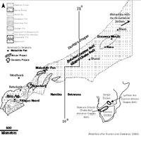
Located 90km southeast of the Namibian capital, Windhoek, the Dordabis Copper Project covers over 470km² (EPL 3257). The project area contains two main copper prospects, Koperberg and RK, which have been the main focus of work to date, including the drilling programmes completed in 2008 by Kalahari Minerals.
A number of other copper showings have also been drill tested which all fall within 2.5km of the main Koperberg deposit (e.g. Swartberg, Klein Koperberg, Koperberg South and Balfour).
Two main styles of mineralisation have been defined at Dordabis; sedimentary hosted and volcanic hosted copper mineralisation.
The sedimentary hosted style of mineralisation is regarded as having the best potential for defining a mineable deposit at the Dordabis Project and is quite typical of similar deposits elsewhere (e.g. in Namibia, Botswana, Zambia, DRC); namely, concentrations of copper mineralisation within fine grained grey-green coloured reduced sedimentary rocks (shale-siltstone-carbonate rocks) in contact with generally coarser grained red coloured oxidised sedimentary rocks (quartzite, conglomerates).
Koperberg, RK, Klein Koperberg, Koperberg South and Balfour prospects are of the sedimentary hosted style of mineralisation which is similar to other known deposits within the Kalahari Copperbelt (KCB) / Ghanzi-Chobe Belt (GCB), which stretches from Klein Aub to the southwest of Dordabis to the Shinamba Hills in Botswana to the north-east, a distance of over 1,000km. The KCB-GCB includes historically mined deposits at Klein Aub (7Mt @ 2% Cu, 50g/t Ag), advanced projects near Witvlei (e.g. see North River's Witvlei Project) and projects in various stages of development in Botswana (e.g. Discovery Metals' Boseto deposit and Hana Mining's Ghanzi Project).
The volcanic hosted style of mineralisation is generally of lower grade and more sporadically developed within the extensive basaltic-andesitic rock units found in the Dordabis area. Known occurrences include Swartberg and Onverwacht (within North River's Dordabis Project).
Koperberg
The Company announced a JORC Resource upgrade at its Koperberg copper deposit in February 2012 following a review of drilling and assay results from previous programmes and additional geological information obtained from diamond drilling completed in 2011.
MSA Group completed its calculations using the existing drill database and its in-house geological model. On this basis, MSA Group has estimated the following using a 0.5 Cu cut-off grade:
Tonnes |
Cu |
Cu |
|
'ooo |
% |
Tonnes |
|
| Indicated | 762.6 |
1.14 |
8,718 |
| Inferred | 617.6 |
0.95 |
5,863 |
RK
Located 1,500m SE of Koperberg, a total of 116 holes have been completed for 13,254m with major intersections including:
- 8m @ 2.3% Cu
- 12m @ 1.2% Cu
- 7m @ 1.7% Cu
Results to date indicate the same style of mineralisation as at Koperberg and similar grades and thicknesses, although over a larger area. An in-house (non-compliant) inferred resource of 1.32Mt @ 1.05% Cu (0.5% Cu cut-off), representing 13,800 tonnes Cu in-situ metal has been calculated for the RK deposit.
The ground magnetic survey and regional mapping currently underway will help define the relationship between Koperberg and RK and also indicate whether the two mineralised areas are linked. Mineralisation remains open at depth and along strike.
Other Prospects
Other prospects in the area have also been drill tested with the following significant results:
Balfour 18 RC holes (1,742m)
- 10m @ 1.1% Cu
- 8m @ 1.19% Cu
Klein Koperberg 14 RC holes (1,380m)
- 6m @ 1.08% Cu
- 14m @ 1.37% Cu, incl. 3m @ 2.37% Cu 4m at 1.88% Cu
Koperberg South 12 RC holes (1,253m)
- 20m @ 0.66% Cu, incl. 2m @ 1.64% Cu and 2m @ 1.32% Cu.
Swartberg 30 RC holes (6,898m)
- 21m @ 0.142 Cu and 0.4g/t Ag
- 47m @ 0.166% Cu and 0.9g/t Ag
Onverwacht 4 RC holes (490m)
No significant assays, with values generally below 0.3% Cu over 2-3m (similar to Swartberg).